 |
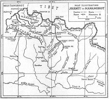
| Map from Tilman’s book |
First European visitors to the Himlung area
We will be walking in the footsteps of giants...
Although very few trekkers now visit the area around Himlung Himal, it was one of the first areas in Nepal visited by white men.
During 1949 and 1950, the famous British explorer and mountaineer H.W. Tilman was one of the first Europeans to visit the
Langtang (1949) and Annapurna Himal (1950), just when the Kingdom of Nepal had opened its borders for foreign travelers.
A travelogue of these first incursions into Nepal was published in 1951 in a book entitled 'Nepal Himalaya'.
Tilman was a famous climber at that moment, he had been the first to ascend Nanda Devi, the highest peak climbed at that time.
The chapters on his Annapurna trekking are very interesting for us Himlung climbers because Tilman visited the same valleys and mountains we will see.
His trip was considered a reconnaissance mission of the Himalayas, they had no plan to climb a high mountain.
Nobody in Nepal spoke English at that time. So they took Major J.O.M. Roberts of the Gurkha Rifles with them, who spoke Gurkhali. Years later Major Roberts would start the first trekking business in Nepal.
At that time there were no roads in Nepal, they had to walk from Katmandu. They left Katmandu May 5th for Trisuli Bazar. From there they went west and then north, passed Besi Sahar, where the roadhead is now. On May 23 they are at Thonje, where Dudh Khola and Marsyandi Khola meet.
They took the 'salt-route' up the Dudh Khola (the 'milk' river) to reconnoiter the Manaslu area, and continued to Bimtakhoti (Bimthang). This is the inverse route some of us walked last year, and from where Johan first spotted the Himlung Himal peak ( or at least what he thought was Himlung ). Tilman made the same mistake. The peak one sees from Bimthang is in fact Nemjung.
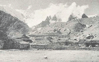 |
| Bimthang in 1950 |
|
|
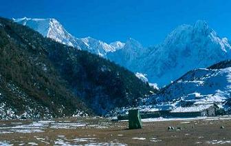 |
| Bimthang in 2002 |
|
Just before they arrive in Bimthang they catch their first glimpse of the Himlung:
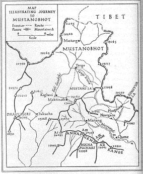 |
Tilman’s crude map of ‘Mustangbhot’. Himlung is NE of peak 22977 (almost) on the Tibet border
|
‘we pushed on, climbing steadily through the forest until the trees ended abruptly halfway up a moraine of white granite boulders. Here the white ramparts of the Ladakh range, several miles to the north, came into sight, and we halted to examine two of its named peaks, Himlung Himal (23,380 ft.) and Cheo Himal (22,350 ft.). We did not think either of the two Ladakh peaks were intended for climbing.’
So little was know at that time of the Himalaya geography that Tilman thought the Himling range was part of the Ladakh range, because it is situated north of the main watershed (Dhaulagiri-Annapurna-Manaslu).
From Bimthang they return to Thonje, and then go north along the Marsyangdi Khola to Manangbhot (Manang), passing through Chame.
While they are staying at Manangbhot, mountaineering history is written 10 kilometers west of them. Indeed, unknown to Tilman, on June 3rd. Annapurna is climbed by a French team lead by Maurice Herzog. This was the first (of the 14) 8.000 meter peaks climbed (Herzog’s book ‘Annapurna’ tells the story of this climb, and their dramatic return to India).
After failing to climb Dhaulagiri from the Kali Gandaki valley in the first half of May 1950, (they could not scale the Dhaulagiri icefall), the French turned their attention to Annapurna. There were no accurate maps and reconnaissance was needed before they could try to scale Annapurna. To see the other side of Annapurna, Maurice Herzog and Gaston Rebuffat went from Jomosom eastward to Tilicho Lake and then to Manang. (We will walk this from Manang to Jomosom).
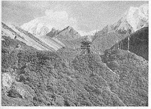 |
The Himlung range as seen by Tilman from Bimthang
|
Both Herzog and Tilman knew of each other’s presence in the area, and the French were even hoping to meet Tilman in Manang, but they were there three weeks before Tilman.
Beginning of June 1950 Tilman’s party tries to climb Annapurna III and Annapurna IV, but this is a failure. They then turn their attention again to the Himlung area. People from Ngawal lead them over Kang La to Naurgaon (Naar):
‘Poised high above the Naur river, the village surprised us by its comfortable and prosperous air. The houses, as usual, appeared to grow out of the brown stony hillside, while below lay terrace upon terrace of young barley of the liviest green, where a swarm of women and children were busy weeding.‘
From Naurgaon they try to climb Khangguru (6.990 meters) in the Himlung range but fail again. Some time later they trek further north to Phugaon (Phu):
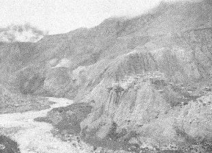 |
| Phu in 1950 |
‘Half a mile beyond the gorge, on the west bank, we came to the strange village of Phugaon built on the face and top of a high cliff of boulders and gravel, the eroded remains of a river terrace.
At first glance it appears to consist of nothing but narrow, clay treshing floors supported on pillars.
Near the village a turbid river emerges from the snout of a big glacier, and on the spur between the two rivers stands a small white gompa and a line of thirteen chortens. Such are the austere features of a harsh landscape where hardly a shrub grows, much less a tree; a landscape of yellow cliffs, white granite boulders, and the grey ice of the glacier.’
From Phugaon they ultimately make a trip east to a mountain pass they call Kongyur La at an altitude of approx. 19,000ft. (5.800 meters). This pass is somewhat north by north-west of Himlung, on the border with Tibet.
From that pass, Tilman and his men, now more than fifty years ago must have had a splendid view of the mountain we intend to climb ..
| 